
Oakdale Neighbors: Block Record Sources
Different Oakdale sources answer different block questions. A city or county GIS layer is best for adjoining parcels, address points, ZIP attributes, plats, zoning, flood information, easements, and land use. The county parcel and recorder routes add a PIN and legal description. A voter record has its own narrow access rules. Public programs and civic organizations can provide a contact route, but the city does not publish a complete neighborhood, HOA, or household roster. Treat each result as a record of its specific subject and date.
| Source | What it shows about a block | Access |
|---|---|---|
| Oakdale and Washington County GIS | Adjacent parcels, address points, ZIP, plats, zoning, flood and land-use layers | Public map or REST layers, not an occupancy roster or survey |
| County surrounding-parcel service | Owner names and addresses for parcels within a specified distance | Paid request with stated use limits |
| MNVotes or a requested voter list | Registration match or limited public voter-list fields | Inputs, statutory purpose, identity, fee, and privacy restrictions apply |
| Oakdale permits and data requests | Address-keyed building and related permit activity where public | Online records after February 6, 2023; earlier records by city request |
| WCHS and MNHS collections | Older occupants, owners, civic participants, obituaries, and address clues | Source and date specific; an index is not proof of current residence |
| Neighborhood Watch and civic resources | Program structure, public contacts, and organization links | No complete member or resident directory published |
Property ownership, tax mailing, and physical occupancy are separate facts. A parcel result may identify an owner or tax contact outside Oakdale; it does not identify every person who uses an address as a home.
For a block question, note the portal, layer or record type, search date, and the exact address or PIN used. That small record trail makes a map correction, a postal mismatch, or a later parcel split visible instead of turning an old result into a permanent statement about Oakdale neighbors.
Note: An address point is a location reference, not a finding about who occupies a nearby home.
Mapping Oakdale Neighboring Parcels
Start with the canonical situs address, which is the physical location used by the address-point or parcel system. Search the Washington County Maps entry point or its linked ArcGIS viewer, then compare the city boundary and address-point layers if the location is near Lake Elmo, Landfall, Pine Springs, or an unincorporated edge. The map establishes a spatial relationship. It is not a surveyed boundary and it does not show who occupies a parcel.
- Find the known address and record the displayed street form, ZIP, and parcel relationship.
- Click only the immediately adjoining or specifically needed parcel polygons and capture each PIN or other stable parcel identifier.
- Use the Washington County property tax lookup with the PIN or property address to review public parcel fields.
- Check the legal description in the recorder route when a map label needs confirmation. Keep the situs address, owner mailing address, and tax mailing address as separate notes.
- For a dated construction question, use Oakdale's post-February 6, 2023 permit search or make a narrow city data request for earlier material.
This process stays focused on the immediate block. For a full named-street record chain, use the Street Directory after the address and parcel are confirmed.
Do not turn a map click into a sweeping list. The county's parcel viewer is useful for a defined spatial question, while the formal surrounding-parcel request is available when a specific radius and its stated access terms are necessary.
Oakdale Neighbors in GIS Layers
Oakdale's GIS map service exposes layers for parcels, address points, plats, zoning, flood zones, wetlands, roads, easements, utilities, existing and future land use, and more. The address-point layer supplies fields such as ZIP and SITUS_ADDRESS, and its query controls support distance, ordering, and statistics. These are location fields. They should not be used to infer a household, a private affiliation, or a legal boundary.
The official layer catalog is visible in this Oakdale GIS service.
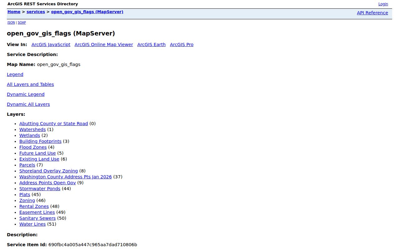
The layer list helps separate map context, such as zoning or easements, from information that must be confirmed in a parcel, survey, or recorded document.
The county survey guidance is especially important when two Oakdale parcels appear to meet on a map. Scaled parcel maps show adjoining land and approximate dimensions, but they are not surveys. Survey records, plats, and legal descriptions remain the appropriate sources for a boundary question.
Oakdale Neighbor Voter Record Limits
MNVotes is designed to check a registration match using first name, last name, date of birth, and either ZIP or county with city, house-number, and street fields. It updates nightly, although registration processing can take time to appear. A positive result concerns registration status at the time of the check, not physical occupancy. It is not a block-by-block resident search tool.
Minnesota Statute 201.091 distinguishes the county auditor's master list from the public information list. The public list can include name, address, year of birth, voting history, and districts, while excluding full dates of birth, government identification numbers, and presidential-primary party choice. Public voter-list use is limited to election, political, or law-enforcement purposes. A safety withholding request or inactive status can also affect what appears.
The Secretary of State's voter-list request form has defined geographic options, delivery formats, fees, and requester fields. Use it only when the request fits the stated rules. A no-match does not prove that a neighbor is absent from Oakdale or from an address.
Note: Voter data should remain a tightly limited civic record, never a substitute for a current household roster.
Oakdale Neighbor Civic Contacts
Oakdale's public neighborhood resources are better used as contact points than as a way to identify households. The city says its Neighborhood Watch model uses resident conversation, an elected captain, meetings, police liaison support, and ongoing communication. It does not publish a neighborhood-by-neighborhood resident list. The city also identifies community organizations and advisory bodies, but their appearances in a public resource list do not establish membership, address, or current residence.
Neighborhood Watch
Oakdale Neighborhood Watch lists Community Affairs Specialist Bill Fetsch, 651-730-2763, as a public program contact.
Police Records
Oakdale Police Department records and non-emergency contact: 651-738-1025.
Boards and Commissions
Oakdale Boards and Commissions identifies five advisory bodies and more than 40 volunteers.
Oakdale Community Resources names the Garden Club, Maplewood Oakdale Lions Club, Chamber, athletic associations, and veterans services. It does not provide a complete member roster. The city's HOA guidance likewise treats association documents and covenants as private, with enforcement handled by the association rather than the city.
A public agenda, volunteer reference, or organization listing can show a civic connection at a particular time. It cannot be converted into a home-address claim or a claim that another Oakdale neighbor belongs to the same group. Use the public contact only for the program or organization it names.
Oakdale Neighbors Across Boundaries
A shared ZIP is not a municipal boundary. Oakdale addresses can use 55042, which may carry a Lake Elmo postal label, or 55128, which may carry a Saint Paul label and also serves Landfall and Pine Springs. The official Minnesota county and ZIP table lists both ZIPs for Oakdale. The postal presentation must be checked with USPS, while the city boundary and parcel jurisdiction should be checked in GIS or county records.
Oakdale's 2024 community survey provides a practical warning: its vendor began with USPS listings but used the municipal boundary to remove out-of-city addresses. Apply the same distinction to nearby-parcel research. Preserve at least four separate fields where relevant: situs address, municipality, postal city, and postal ZIP. Do not turn a shared delivery label into a statement about an Oakdale neighbor.
Historic geography needs the same discipline. Oakdale Township, East Oakdale, Northdale, Lake Elmo, Bass Lake Station, and other older labels may describe the same general area at different times, but they are not interchangeable.
Street names can add another mismatch. Oakdale Ordinance 920 renamed Healy Avenue North and Healy Lane North to Heath Avenue North and Heath Lane North. Preserve both forms when comparing an older property clue with a current map point, parcel record, or legal description.
Note: Keep postal delivery labels separate from city jurisdiction whenever a nearby parcel falls near a municipal edge.
Oakdale Neighbor Sources Compared
Official and commercial neighbor tools serve different purposes, but neither can make a reliable present-occupancy list. Official sources disclose their subject matter, access channel, dated layer, or legal restrictions. Commercial category tools may combine public and other information with less clear update timing and matching rules. A map, a tax record, a voter status, and an old directory entry all have different limits.
| Source category | Useful for | Limit to keep |
|---|---|---|
| Official map and parcel records | Location, PIN, adjoining-parcel context, legal and tax research | Does not establish a current household or survey boundary |
| Official civic and voter channels | Public program contact or a permitted registration-related purpose | Purpose, privacy, and field restrictions remain in force |
| Commercial neighbor category | A possible lead that requires independent checking | Source date, matching method, and current accuracy may be unclear |
For a defined radius of properties, the county's surrounding-parcel service is the formal route. It costs $50 for up to 25 parcels including the subject parcel, $0.50 for each additional parcel, and $1 per mailing-label sheet. The county restricts business use involving surveys, marketing, or solicitation, so narrow the request before making it.
Oakdale Neighbor Privacy Limits
Some records are intentionally unavailable or incomplete. Minnesota Safe at Home, under Chapter 5B, gives eligible participants a substitute address and mail forwarding while keeping the real address secure. Never treat a designated address as an ordinary location or try to reconstruct a protected address from older material. Voter withholding, inactivation, sealed records, private HOA documents, and a missing public list can also limit a result.
For a threat, unwanted contact, or possible protected-person situation, stop the search and use the official route. Minnesota's data-practices rules begin with public access but allow classified data to remain private, confidential, nonpublic, or otherwise restricted. A result that conflicts across sources needs a dated agency record, not extra inference.
Lawful use. Use Oakdale block records for personal, civic, or property-context questions. Do not use them to watch, harass, intimidate, or harm anyone; Minnesota law prohibits stalking and related conduct.