
Oakdale Previous Residents by Era
Different sources answer the question of past Oakdale residents at different points in time. The deed record is the best legal ownership trail. Dated plats and local history sources can connect an older landowner or place label with a parcel. Directories, newspapers, and census material can add a household clue, but only if the particular volume, year, and place cover the address. No single source found in the research provides a complete, continuous resident list for every Oakdale address.
| Source | Years it covers | Where held | What it can show |
|---|---|---|---|
| RecordEASE land index | Stated 1984 forward online | Washington County Recorder portal and research room | Recorded transfers, grantor or grantee, legal description, and instrument details |
| WCHS local sources | Specific sources include 1871-1900, 1881, 1889-90, and 1901 | WCHS Name Index and source materials | Historical name, deed, cemetery, township vital, plat, and business-directory leads |
| Washington County plat book | 1938 | Library of Congress catalog collection | Township, city, village, subdivision, and landowner context, including an East Oakdale insert |
| MNHS directory or telephone search | Up to five selected years per request | Minnesota Historical Society research service | A one-name check in city directories, telephone books, or both |
| Oakdale permit file | Online after February 6, 2023; older records by request | City OpenGov and city data-request process | Dated public address activity, not a household roll |
Choose the era first. A remote deed search is often the first move for a recent transfer. A township, plat, or archive trail is more useful when the address predates the city’s current form. Preserve gaps instead of filling them with a guess.
Oakdale Previous Residents Start With a Parcel
Begin the backward trail with today’s property key. The Washington County property tax lookup accepts a PIN or a property address. Its address instruction calls for the house number and street name without a suffix. A matching result may show the PIN, situs, owner or tax-mailing fields, values, classification, and legal description. Record the source date and the exact displayed terms before moving to older material.
The tax result does not establish occupancy. An owner can have a different mailing address, and a situs identifies a property rather than a household. The county map viewer and Oakdale address points can confirm the physical parcel and current street form. Their role is to anchor the search in a location, not to identify the people who lived there.
Use the PIN and legal description together. A street address can be renamed, renumbered, split, or assigned a different postal label. The legal description is more likely to carry across a land-record chain.
Oakdale Previous Residents Deed Chain
Washington County Recorder records form the backward ownership path for an Oakdale address. Start with the current parcel and use the legal description to find the transfer into the current owner’s name. The document identifies a legal transaction, not a continuous residence. Follow the recorded parties one transfer at a time, marking document number, recording date, instrument type, and legal description. A mortgage, lien, or plat may help explain the parcel history but is not automatically a transfer of ownership.
- Save the present PIN, situs, and legal description from the county property result. Compare the mapped parcel so the starting property is not a same-street match.
- In RecordEASE, locate the purchase record with the current owner as grantee, then compare the address and legal description shown by the document index.
- Record the grantor, the person or entity conveying the interest. Search that prior owner as a grantee to find the earlier acquisition.
- Repeat the transfer-by-transfer check backward, keeping a list of changes in legal description, plat, lot, block, or parcel number.
- When the online trail reaches its coverage edge, ask the Recorder research room about older electronic images, index access, and the particular record needed.
The research room is at 14949 62nd Street N in Stillwater and is stated to be open Monday through Friday, 8:00 a.m. to 4:15 p.m. Recorder or Registrar contact is 651-430-6175. The Washington County property-records page provides the current access route and recorder information.
RecordEASE for Oakdale Previous Residents
RecordEASE is the county’s secure land-record platform. The county states that its online index reaches 1984 forward for abstract and Torrens records. Search paths include grantor, grantee, legal description, recording date, address, metes-and-bounds, tax lien, plat, tract card, and historical tract page. Older documents may have been converted to electronic images, but the age and availability of a particular index entry or image must be checked rather than assumed.
The Washington County RecordEASE access page is the appropriate portal for this portion of an Oakdale house-history search.
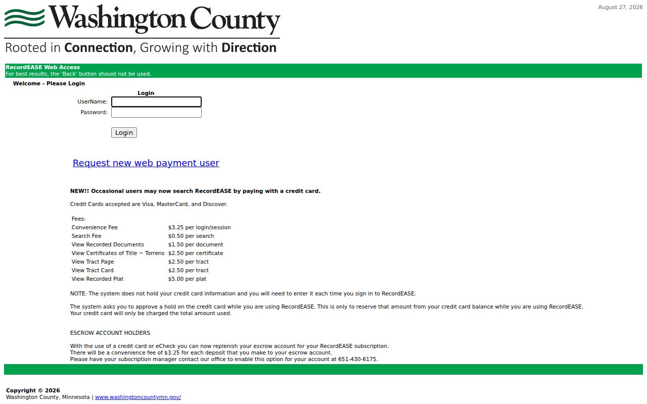
Occasional access is listed at $3.25 per session, with $0.50 per search and $1.50 per document among the listed transaction charges. The page also lists a $30 monthly subscription, certificate and tract-page charges, and a $5 recorded-plat charge. Confirm the current screen before payment and keep the citation for each document.
RecordEASE prohibits screen scraping and multiple-parcel downloads. A careful history uses individual records and document citations, not a bulk export of names or parcels.
Oakdale Past Residents and Land Systems
Washington County uses abstract and Torrens systems. Most county land is abstract land, where an abstract summarizes recorded documents. Torrens land is registered land with a Certificate of Title treated as conclusive evidence of ownership subject to statutory exceptions. A transfer that involves a title certificate, examiner of titles, probate, trust, or court order can require a different document path than a routine abstract deed.
- Grantor
- The party who conveys an interest in a recorded document.
- Grantee
- The party receiving that interest. In a purchase chain, a former owner may first appear as a grantee on the earlier acquisition.
- Chain of title
- The linked sequence of recorded transfers or title events associated with the same legal property description.
- Legal description
- The formal lot, block, subdivision, metes-and-bounds, or other land description used to distinguish property more reliably than a changing street label.
- Abstract and Torrens
- Two land-record systems that determine how the title history and supporting records are read in Washington County.
These terms identify land interests. They do not prove that a grantee, grantor, trustee, or mailing contact lived at the property.
Oakdale Previous Residents and Old Names
An old Oakdale address may not use the name printed on a current tax bill. Ordinance 920 renamed Healy Avenue North and Healy Lane North to Heath Avenue North and Heath Lane North. Search both names when comparing deeds, plats, newspaper notices, or directories. Keep the original street spelling, current form, and ordinance reference together so an address trail can be checked later.
Place names can change too. WCHS documents a township formed in 1858, the Lake Elmo split in 1926, East Oakdale’s detachment in 1951, later Northdale and East Oakdale changes, and city status in 1974. A historical record can therefore use Oakdale Township, East Oakdale, Northdale, Lake Elmo, Bass Lake Station, Lohmanville, or Halfway House. The WCHS Oakdale history helps interpret the label, but a dated record is still needed to connect it with a particular parcel.
Note: Store a historical place label as it appears in the original source, then add the modern Oakdale relationship only when the dated map or record supports it.
Oakdale Previous Residents in Plats
Plats provide dated land context rather than a household list. The WCHS Name Index contains more than 180,000 listings across histories, censuses, cemeteries, directories, deeds, and biographical files. Its source inventory identifies 637 entries for the 1881 Washington County history, 1,856 for the 1901 plat book, 247 deeds, and 3,993 scrapbook-index entries. It also lists 265 Oakdale death entries from 1871-99, 669 township birth listings, and 59 township death entries. Counts can change as the index grows.
The WCHS Name Index is a lead system. Request or inspect the underlying source before treating a result as a dated connection to an address. The 1938 Washington County plat book includes an East Oakdale Township map insert and can bridge a period between older plats and later county records. Preserve the map date and its landowner context.
No Oakdale-specific Sanborn sheet was verified in the Library of Congress collection search. Nearby fire-insurance maps should not be relabeled as Oakdale evidence. That gap makes plats, surveys, aerials, deeds, newspapers, and archival records more important for a defined property question.
Oakdale Previous Residents and Directory Gaps
Historical directories can add a household clue after the ownership chain is clear, but the verified Oakdale coverage is limited. WCHS lists Polk’s Dual City Business Directory for 1889-90, with 1,563 indexed listings. It is a business-directory clue, not a complete household directory. No complete Oakdale reverse-directory run was verified, and no verified complete later Oakdale household or business directory series should be assumed.
The MNHS city-directory search request can search one individual or business name in up to five years of one city’s city directories, telephone books, or both. The stated fees are $10 for city directories, $10 for telephone books, or $20 for both, including a nonrefundable $5 processing component. Scans or email are included; the usual turnaround is three to four weeks and can extend to 12 weeks.
Regional St. Paul and Hennepin County directories are cross-checks for nearby movement, not an Oakdale directory series. A targeted question should state the name, city or town, selected years, and any address or place-name variant. The historical shelf itself is described on the Oakdale directory book.
Oakdale Past Households With Census
Owners are only one part of the previous-residents trail. A dated directory, census return, newspaper notice, obituary, cemetery entry, or probate file can provide a household or relationship clue. Each source has a different purpose. A plat may name a landowner. A cemetery entry identifies burial. A deed identifies a legal transaction. None alone proves a person lived continuously at the address.
- Choose the target year and the historic place label used at that time, such as Oakdale Township or East Oakdale.
- Use the deed or plat to identify the owner, legal description, nearby road, township, or subdivision for that period.
- Search WCHS for a source-specific name lead, then compare a directory or telephone request for the same person and selected years if coverage exists.
- Pair the dated name and place with the applicable census material, preserving the township or place context rather than forcing a modern street address onto the record.
- Check newspapers, cemetery records, or probate only as a dated supporting layer, and request the original page when an index entry is not enough.
Washington County Library’s genealogy resources point to newspaper and database tools. Microfilm or microfiche machines are identified at the R.H. Stafford Library in Woodbury and the Law Library at the Stillwater Government Center, not at the Oakdale branch. These access channels matter when the online index stops at a citation.
Limits on Oakdale Previous Residents Research
Past residents should be described at the level the record supports. A deed chain establishes legal transfers. An address point establishes the current mapped location. A directory, census, obituary, or historical index can suggest a dated household connection. It does not follow that every named party lived at the property, remained there for a full period, or represents every person in the home. A negative online result can be a coverage or access limit, especially before the stated 1984 RecordEASE index range.
For earlier Oakdale city permits, use the city data-request process rather than treating an online absence as proof. The OpenGov permit search is limited to records after February 6, 2023. Older material requires a narrow request by address, period, and type. Keep protected addresses, sensitive information, and uncertain name matches out of a house-history summary.
Lawful use. Oakdale house-history research belongs to personal, family, estate, and property questions. Minnesota Statutes section 609.749 prohibits using historical or current records to stalk, harass, threaten, or monitor a living person.