
Search Oakdale Streets by Address
A useful Oakdale street directory search follows one address at a time. Start by confirming the street number and current spelling, then use the parcel record to identify the PIN and the administrative owner fields. The recorded deed supplies the legal transfer trail. A voter-registration lookup can only confirm a registration match when the required identifying information is already known, and it is not a street roster. Last, use a dated historical directory lead only when a source actually covers Oakdale. This order keeps ownership, mapped location, and household evidence separate.
- Enter the house number and street name, without the street suffix, in the Washington County property tax lookup. Select the matching PIN and save the situs spelling and search date.
- Use the county or city map to compare the PIN, address point, parcel shape, and nearby street labels. A map click helps identify the property; it does not establish who occupies it.
- Search the same legal description, address, or named parties in RecordEASE. Work backward from the buyer on a deed to the earlier seller instead of assuming the current owner is a resident.
- For a lawful, individual check, use Minnesota Voter Registration Lookup with first name, last name, date of birth, then ZIP or county, city or town, house number, street, and an optional unit. Treat a result as a registration match, not proof of an entire household.
- For an older address question, seek a specific WCHS or MNHS directory, plat, newspaper, or census lead. Record its date and source before describing a past household.
Work in narrow sets. The county prohibits screen scraping and multiple-parcel downloads from RecordEASE, and a broad sweep turns a useful street-by-street task into an unreliable collection of mismatched names.
Oakdale Street Directory Parcel Search
The county tax screen is the practical first record for an Oakdale street directory search. It offers a Parcel ID Number, also called a PIN, and a Property Address field. The address instructions are precise: enter the house number and street name only, not a street-type suffix. A result can lead to a selectable PIN, situs address, owner and tax-mailing fields, values, and classification. Those are property-administration fields. They should never be converted into an assertion that an owner or mail recipient lives there.
| County search label | How to use it |
|---|---|
| Parcel ID Number (PIN) | Use when a map, deed, or prior tax record already supplies the parcel identifier. |
| Property Address | Enter the house number and street name only; leave off the street suffix. |
| Search | Review the matching parcel and select its PIN before relying on any result fields. |
| Parcel result | Preserve the displayed situs, owner or tax-mailing field, classification, values, and date as distinct facts. |
The county property lookup is shown with its PIN and address entry paths in this captured view.
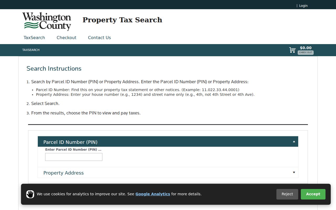
Use the selected PIN as the bridge to the map and recorder rather than treating the screen as a resident list. Values and payment information change, so the live result and its date remain important.
For a limited paper or data request, Washington County Property Records and Taxpayer Services is the county route. A request that names a PIN, document type, and time period is easier to reconcile than a vague request for everyone on a street.
Oakdale Street Directory Map Fields
Washington County Maps and Oakdale GIS help standardize the address before any title work begins. The county viewer accepts an address or PIN and lets users choose layers. Oakdale’s address-point service is more specific: its fields include SITUS_ADDRESS, ZIP, legal-line information, parcel zoning, numbered address components, and an object ID. The service can query, paginate, order, calculate statistics, and make distance queries, with a stated maximum of 2,000 records or selections. Those controls describe a geographic layer, not a people lookup.
The Oakdale address-point layer exposes the field names that help normalize an address before comparing records.
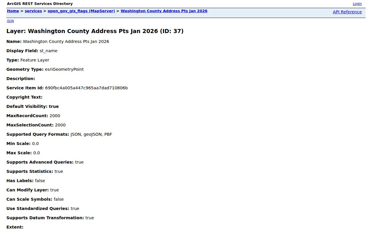
That layer can supply a current postal ZIP and canonical situs string. It cannot establish occupancy, a unit-level household, or the legal edge of a parcel.
Use the Washington County Maps entry point for county parcel and recorder layers, then compare the city boundary layer near Lake Elmo, Landfall, Pine Springs, or an unincorporated edge. A county-maintained point does not by itself settle the municipality for every nearby address.
Oakdale Street Address Records
Several public systems can be searched by street or connected through a parcel key. They have different dates and limits. The strongest Oakdale street directory result names the record type first, then says only what that record shows. An address point is a location record. A tax entry is administrative property data. A deed is a legal transaction. A permit is an activity trail. None is a complete, current list of people on a street.
| Address-keyed source | Custodian | Useful result | Access boundary |
|---|---|---|---|
| Address points | Oakdale GIS and county GIS | Canonical number, street, situs, ZIP, and parcel relationship | Public map or REST layer; current data and query limits apply |
| Tax parcel | Washington County PRTS | PIN, situs, owner or tax mailing, values, and classification | Public PIN or address lookup; result fields vary |
| Recorded document | Washington County Recorder | Grantor, grantee, document date, legal description, and instrument type | RecordEASE or research room; coverage must be checked |
| Plat or survey | County Survey and Recorder | Lot, block, subdivision, adjoining parcels, and survey evidence | GIS, plat view, and office records; a map is not a survey |
| Building permit | City of Oakdale | Public address-keyed permit activity and status | Online for post-February 6, 2023 records; earlier material by data request |
| Voter registration | Secretary of State and county elections | An individual registration match or limited lawful list fields | Purpose and privacy limits apply; full birth dates and IDs are excluded |
When a parcel changes shape or a road name varies, the legal description and PIN offer better continuity than a casual street label. Keep the source date with each field, especially a ZIP or address point that may later be corrected.
Note: A property owner, mailing address, map point, and registered voter are separate records and should remain separate in every Oakdale street research note.
Oakdale Street Directory Deed Trail
For an Oakdale property question, the Recorder’s RecordEASE index is the document trail after the PIN is known. The online index is stated as 1984 forward for abstract and Torrens land records. It supports grantor and grantee names, legal descriptions, recording dates, addresses, metes-and-bounds, liens, plats, and tract materials. Older documents may have converted electronic images, but their index fields and image availability must be verified for the particular record rather than assumed from the later online range.
Occasional users of RecordEASE are listed at $3.25 per session, with listed charges of $0.50 per search and $1.50 per document. The county also lists a $30 monthly subscription and separate charges for certificates, tract pages, and plats. Confirm the live fee display before payment.
The Recorder research room at 14949 62nd Street N in Stillwater is open Monday through Friday, 8:00 a.m. to 4:15 p.m., with Recorder or Registrar contact at 651-430-6175. The county property-records page is the source for current counter access, copies, and abstract or Torrens procedures.
Oakdale Street Permits by Address
A permit can date construction, repair, or other recorded activity at a particular Oakdale address. It is not proof of a household. The city’s Building Permits page directs users to OpenGov for records after February 6, 2023, searchable by address or permit number. The date boundary matters. A missing online result can reflect the cutoff rather than the absence of an earlier permit.
For an earlier address record, use the city’s Data Request route and describe the parcel, address, period, and record type. Minnesota’s public-data rules allow inspection of public data, while classification and copying rules still control the response. The city may need to separate public and nonpublic material before providing copies.
Use permit timing as a property-history clue beside the deed date, parcel number, and legal description. Do not treat a named applicant, contractor, or mailing contact as an occupant without independent, appropriate evidence.
Oakdale Street Directory Terms
Property records use a few terms that are easy to blur when comparing an old deed with a current street map.
- Parcel
- A defined piece of land used in county assessment and mapping. Its PIN is the county identifier that helps connect tax, map, and land records.
- Situs address
- The physical location assigned to the property. It is different from an owner or tax mailing address and does not name every person at the location.
- Plat
- A recorded map that lays out lots, blocks, streets, or subdivisions. It can help match an older legal description to a mapped location.
- Criss-cross directory
- An address-arranged directory that may point to a household or business for the date and coverage of that particular volume.
A term’s date matters as much as its label. A current situs string can be a poor substitute for the legal description used in an older recorded instrument.
Healy and Heath Street Names
Oakdale’s street records have a documented address-alias issue. Ordinance 920 renamed Healy Avenue North and Healy Lane North to Heath Avenue North and Heath Lane North. Search both forms when a deed, plat, newspaper notice, directory entry, or old map gives one name and a current address point gives the other. Preserve the original spelling in a note, then attach the current form and the ordinance source. That is more reliable than silently rewriting a historical address.
Oakdale’s older geography adds more possible labels. A historic reference may say Oakdale Township, East Oakdale, Northdale, Lake Elmo, Bass Lake Station, Lohmanville, or Halfway House instead of the city name used today. The Washington County Historical Society’s Oakdale history helps place those names in context, but a place reference still needs a dated plat, deed, newspaper, or map before it is tied to a modern parcel.
The complete historical collections belong with the Oakdale directory book. For a single street question, use only the exact volume or source that covers the year under review.
Oakdale Street Maps and Surveys
Map layers are strong evidence for spatial questions: which parcels touch, whether an address point falls within a city layer, and which plats, zoning, easement, water, or sewer layers are present. The county Survey office also identifies aerial-photo intervals from 1936 through 2019, generally every five to ten years. Those images can give a dated view of change around a street without identifying the people connected with it.
The Washington County Survey page distinguishes a scaled parcel map from a survey. Parcel-map dimensions are approximate and do not settle a boundary question. Surveys can be viewed at 11660 Myeron Road North in Stillwater, and the stated copy rule allows photocopies of surveys dated before March 1, 1989. For a boundary issue, use the survey or registered land survey, not the street-directory map layer.
Note: Aerials, zoning, and parcel shapes explain the setting of an Oakdale address but do not establish a household, ownership right, or legal boundary by themselves.
Limits of Oakdale Street Directory Results
An Oakdale street directory cannot provide a definitive household roll. The tax portal identifies property administration, not occupancy. The city address-point layer standardizes location, not residents. Recorded deeds identify legal transactions, not continuous residence. MNVotes is an individual registration form with required matching fields, while a voter list is limited by Minnesota Statutes section 201.091 to election, political, or law-enforcement uses. It does not disclose full birth dates or government identification numbers.
Historical sources have their own limits. WCHS and MNHS indexes can lead to a name, landowner, obituary, cemetery record, or directory listing, but an index entry is not a complete original record. No complete Oakdale reverse-directory run was verified, so no search should imply that a street has been exhaustively covered across all years. A result that fails to appear may simply fall outside the record’s date or access boundary.
Lawful use. Oakdale address research is for personal, lawful purposes such as family or property history. Minnesota’s harassment and stalking law, section 609.749, prohibits using records to stalk, harass, threaten, or monitor another person.